


 |
Berkeley Archaeology
The Archaeological Research Facility Newsletter
|
A Study of Holocene Environmental Changes and Human Responses
Barbara Voytek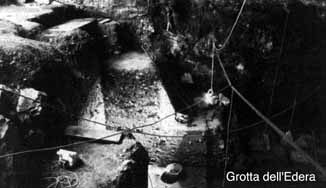 Grotta dell'Edera is one of over 100 caves that are located in the karst surrounding Trieste, Italy. Several of the caves have, like Edera, evidence for human occupation during both Mesolithic and Early Neolithic periods which in this area date to the 6th and 7th millennia BP. The caves of the karst are found on both sides of the border, and given that the border has changed over the past 50 years or so, many of the caves have two names, one Italian and one Slavic - for example, Vlaska jama=Caverna del Pettirosso; Pecina na Leskovcu=Grotta Azzurra.
Grotta dell'EderaThe interesting history and cultural traditions of the karst are matched by the geological setting. Karst is a limestone terrain characterized by several geological features. Sinkholes or sinks are common in the landscape, as are small depressions known regionally as dolinas. Surface water is scarce, but there are underground streams and rivers draining into the sea. Some of the caves in this region are well-known for their Pleistocene record. For example, not far from Edera is the well known cave of Visogliano which has Middle Pleistocene fauna and lithic industries described by the excavator as 'Clactonian'.
Grotta dell'Edera was first documented in 1969 during a detailed survey of the caves in this particular area of the karst. In 1974-75, archaeologists from the Society for the Prehistory and Protohistory of the Friuli-Venezia Giulia Region excavated three one-meter sectors. The majority of their finds were chipped stone tools, affiliated with Mesolithic and Epipaleolithic industries. Although all excavations had been systematically done and incorporated screening techniques, no attempt had been made to retrieve botanical or other samples for environmental reconstruction.
In September of 1992, a new joint Italian-US project was launched at Edera, with the assistance of a grant from the National Science Foundation. Four square meters were excavated to a depth of approximately 3 meters. In 1993, with support from the Stahl Endowment Fund, another 50 cm were excavated. Pollen samples were taken, flotation samples were processed, and all excavated soil was water-screened with 2 mm screens. The excavations were directed by Dr. Barbara Voytek, representing the Archaeological Research Facility at the University of California, Berkeley, and Professor Paolo Biagi, of the Department of History and Oriental Studies at the University of Venice. The student archaeologists came from UC Berkeley, the University of Venice, the University of Leicester, and the University of Belgrade.
A sequence of deposits was uncovered with several undisturbed fireplaces and cooking floors dating from the Roman to the Early Neolithic periods. The Early Neolithic pottery is undecorated and poorly fired, while the chipped stone tools are morphologically the same as types found in the Mesolithic period of the region and are made of local flint. These cultural materials were found in association with a fireplace or firepit that was full of marine shells (Patellae and Trochus). The shells clearly represent the remains of a meal. Their presence suggests that this level and the feature date to the early Holocene when the sea level had risen considerably. Edera is part of a larger regional research project to examine the process or processes of neolithisation in the Northern Adriatic during the late 8th to early 6th millennia when the earliest evidence for food production is known from that area. In this respect, the Early Neolithic levels are especially important to our efforts in exploring the links between the environmental changes of the Holocene and the economic changes of the Early Neolithic.
Patrick V. Kirch
The Archaeological Research Facility has been so active this past year that we have had to expand the current issue of Berkeley Archaeology to six pages! Highlighted in these pages are two important excavation projects in Europe: the Grotta dell-Edera cave excavation directed by Dr. Barbara Voytek and Ruth Tringham's new social archaeology project in Bulgaria. ARF faculty and student researchers continue to be active in many other parts of the world, however, as field teams are now making preparations for projects in France, Bolivia, Hawaii, and even such exotic locales as Fort Ross, California.
We are also pleased to announce the pending publication of ARF Contribution No. 52, "Toward a New Taxonomic Framework for Central California Archaeology," which will be available later this spring.
Christine Hastorf has joined the Department of Anthropology and the ARF this spring semester as an Associate Professor. She received her PhD from UCLA in 1983 where she began her research in Andean archaeology and paleoethnobotany. Between then and 1994 she taught in the Anthropology Department at the University of Minnesota where she organized an archaeobotany laboratory and conducted archaeological fieldwork throughout the Andes in Peru, Argentina and Bolivia. With her move to UCB she will also form an archaeobotanical laboratory in Kroeber Hall which will house thousands of charred archaeobotanical specimens from South America as well as modern plant type collections. This laboratory work focuses on the identification of ecofacts from excavations as well as basic research on methodological and interpretive issues including processing experiments, to learn about past activities with the plants and their deposition, modern sample analysis, and cooperative research with natural scientists on DNA identifications, plant morphology, and microscopic techniques such as phytolith analysis. In addition she will participate in teaching the core archaeology classes as well as classes on subjects such as Andean Ethnography and Archaeology, Paleoethnobotany, Environmental Archaeology, Political Complexity and Foodways. She is actively involved in field work and has directed a series of excavations in the Andes. Her current work is on the social value of food and its active and interactive role in political and social change.
Ruth Tringham
In July 1993, Dr. Ruth Tringham along with Dr. Douglass Bailey, visiting Lecturer, Dept. of Archaeology, University of Wales at Cardiff in UK, and a group of students from the Dept. of Anthropology, Berkeley (Mirjana Stevanovic, Jason Bass, Kathryn Prizer, Arlika Ruby); and Heike Neumann, doctoral candidate of the Dept. of Archaeology and Geography, University of Wales at Cardiff, started the preliminary reconnaissance for a long-term archaeological project in Northeast Bulgaria.
Recent social and political changes in Bulgaria have made it feasible to plan a collaborative project there of the kind that Professor Tringham has been carrying out until now in Yugoslavia. For ten days the team participated on the excavation of a tell-Mednikarovo-in south-east Bulgaria. The excavation was directed by Dr. Stefan Aleksandrov of the Thracian Section of the Archaeological Institute, Sofia. The Mednikarovo excavation, near Galabovo, was being carried out under the auspices of the Maritsa Isotok Archaeological Conservation Project, headed by Dr. Ivan Panayotov. The aim in 1993 was surface and sub-surface reconnaissance of the multi-period (Bronze Age/Eneolithic/Neolithic) tell settlement, which is threatened with eventual destruction by coal-mining activities.
The Berkeley team was lending its minds and bodies to this project as a "practice run" of collaboration in Bulgaria. They wanted to see what it was like to excavate with Americans, since no such collaboration had been experienced by the Bulgarian archaeologists, although collaborative excavations have been experienced in recent years with Soviet, French, German, Austrian, Polish, and even Japanese archaeologists. We excavated with Bulgarian local
museum staff, students and farm workers.
The tell is a 6 meter high mound formed entirely of cultural debris from ca. 2500 years occupation. Our main effort here was to map the site, establish a grid and excavate test trenches in two areas of the tell. We excavated a step trench 2 meters wide that ran from the approximate middle of the tell towards its northern edge along the N-S line. It was 60 meters long, and was divided into 5 steps.
This was a strategy chosen to give us information on the duration and rough chronological sequence of the settlement of the tell, that would be feasible to finish in the 8-10 days of excavation at our disposal. The step trench gave us information that the bulk of the upper levels of the tell dated to the Early Bronze Age Ezero culture, and the Late Eneolithic Karanovo Vib culture. In addition, the soil matrix, through which we were excavating was about the hardest and most unforgiving and uninformative that I have ever encountered in Europe!
On the steep southern edge of the tell we cut a trench (3.50x2.30m.), hoping to get a clear vertical profile of the tell's stratigraphy. It was excavated to a depth of 5 m. below the modern surface. We did not get the clear stratigraphy that we had expected. Instead this part of the tell appeared highly disturbed, comprising a large Early Bronze Age garbage pit with comparable material to the upper levels of the step-trench. The EBA pit was dug through the barely discernible remains of Late Eneolithic (Karanovo VIb) culture layer. It was also dug into a large Middle Neolithic (Vesselinovo culture) pit that lay beneath it. This pit contained a rich variety of Neolithic materials including decorated ceramics and other fired clay artifacts.
Our conclusion about the site of Mednikarovo is that it was settled first during the Middle Neolithic Vesselinovo culture (ca. 5000 BC), that it was then probably abandoned until the Late Eneolithic Karanovo VIb culture (ca.4000 BC), when it was re-settled and continuously occupied until the Early Bronze Age Ezero culture (ca. 3000 BC).
The second ten days were spent in a very different milieu and a different enterprise. This was a mapping and surface reconnaissance project of the Eneolithic tell of Podgoritsa, near Turgovishte, in the agricultural north-east Bulgaria. The tell settlement of Podgoritsa is the focus of what we hope will be a longer term joint US-Bulgarian research project. We carried out the important preliminary task of mapping and surface collecting the site as guests of the Regional Museum of Turgovishte, our collaborator being their head archaeologist, Dr. Ilke Angelova.
The tell is a mound ca. 5.5 meters high. The size at its base is ca. 80 m diameter, at its top considerably less. Thus Podgoritsa tell is an average size for the settlement mounds in NE Bulgaria, which are in general smaller than those of the Maritsa Valley in SE Bulgaria.
The tell of Podgoritsa lies ca. 10 km northwest of the town of Turgovishte, in quite an idyllic spot. The sound of cicadas is deafening! It is located in the watershed area of the Golyama Kamchiya river that runs east to the Black Sea, and a tributary of the Beli Lom and Cherni Lom rivers running north to the Danube. A spring lies 50 m east of the base of the tell. The tell lies in the middle of fertile alluvial soil, close to outcropping high quality flint in deposits to the north and northeast and 20 km north of the northern edge of the Stara Planina mountains that rise at this point to a height of ca. 1000 m asl. the Stara Planina, and south of them the Sredna Gora mountains are rich in mineral wealth, including copper minerals, and gold, as well as varied macro-crystalline rock deposits.
The research project at Podgoritsa builds on intensive archaeological research already carried out in the region. The project is expected to provide an arena where the familiar and richly preserved architectural and other material remains of the early agriculturists of Southeast Europe can be investigated with a different theoretical framework and strategy of excavation and analysis from that with which they have been traditionally investigated.
In the fields in the immediate vicinity (50m) southwest of the Podgoritsa tell have been found indications of a cemetery. This would not be unexpected, but is an exciting prospect for research. Cemeteries occur in close association with Eneolithic settlements only in Northeast Bulgaria. They are always west of the settlement, and within 100 m distance. Some of the cemeteries have been excavated. Those on the coast, especially that at Varna, have produced spectacular metal (gold and copper) finds. Those inland such as at Vinica, Devnya and Golyama Delchevo have a wealth of information but rarely metal among their grave-goods.
Our research this summer represented the first research at the tell itself. We made a 1:200 map of the tell of Podgoritsa, and one at 1:1000 of the area immediately surrounding the tell. Surface mapping and collection of archaeological materials revealed a rich assemblage of Middle Eneolithic ceramics, burned clay house rubble, faunal and lithic materials. The cleaning of the debris of badger holes showed that in the deeper levels there are materials dating to the Early Eneolithic.
The tell has not been cultivated so that its stratigraphy has not been disturbed by ploughing. Its northern side has been subject to dense bushy vegetation whose roots penetrate at least 30-40 cm and it has been disturbed by animal burrowing (badger) and some human looting (the trench ca 30-50 cm deep scraped up its eastern side). On the whole, however, we expect the preservation of occupation levels to be excellent.
Thus the Podgoritsa tell covers a period of prehistory that is rather different than the deposits of Mednikarovo. This period, however, coincides with the periods of my previous research projects in Yugoslavia: Opovo and Selevac. The research this summer enabled me to confirm that this was an exceptionally suitable project for my future research in Bulgaria, focusing on the social archaeology of houses, and the life-histories of households in prehistoric SE Europe.