


 |
Berkeley Archaeology
The Archaeological Research Facility Newsletter
|
Ishi Was Not Necessarily the Last Full-Blooded Yahi:
Some Inferences For Hunter-Gatherer Style and Ethnicity
M. Steven Shackley
 Recent research on the projectile point style, physical anthropology, and the oral history of surrounding historic Native California groups suggests that Ishi, purported to be the last California Yahi of the early 20th century, appears to have learned much of his technology from members of an adjoining group.
In 1990 I began a metric and morphological analysis of Ishi's stone tools curated by the museum from the period between 1911 and 1916 when Ishi lived at the museum, then in San Francisco. While there was some observation of Ishi's stone tool production by Saxton Pope and Nels Nelson at the time, no one had really analyzed the debitage, cores, projectile points, and knapping tools he produced and used, particularly with an eye toward addressing current theory in archaeology and lithic technology.
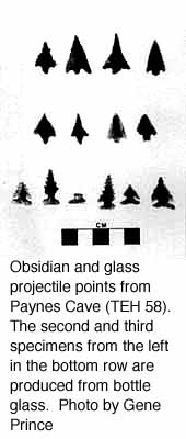
As part of the study, I compared the metric and morphological data of Ishi's projectile points to those from historic Yahi and Southern Yana contexts in collections from Kingsley (CA-TEH-1) and Paynes Caves (CA-TEH-193) housed in the museum, excavated in the 1950's by Martin Baumhoff, then a graduate student in the Department of Anthropology. Immediately apparent was the extreme difference in form and metric attributes between Ishi's assemblage and the points from historic Yana contexts. While at the museum, Ishi produced almost exclusively triangular, concave-based side-notched points with relatively large blades, and triangular, expanding stemmed, corner-notched points mainly with straight bases; the notches are typically "keyhole" notches produced by using the "point-of-tool" method of notching. These styles were almost completely absent from the historic sites, and one side-notched point recovered from Kingsley Cave was produced from a brown chert absent in the region, and possibly exchanged as a finished tool.
Another line of evidence strengthens the inference that Ishi consistently produced points dissimilar to the Yahi. In 1908 when a group of engineers came upon the last four Yahi, including Ishi, on Deer Creek they stole many of the artifacts from the camp. The group consisted of an old man, an old woman, a young woman, and Ishi. One of the arrows, now at the Hearst Museum, is tipped with a glass arrow point. This point, based on an x-ray, is a triangular, expanding stemmed, corner-notched point with a straight base, morphologically identical to those produced by Ishi at the museum, but dissimilar to the forms recovered from the Yana sites. While we will never know if Ishi actually produced this arrow (apparently no one thought to ask him), the evidence suggests he did. In 1990, the research stopped at this point with way too many questions.
In 1994, Jerald Johnson, an archaeologist working in the southern Cascades, and a member of the Department of Anthropology at California State University, Sacramento, presented a paper at a conference devoted to Ishi at the Oakland Museum just before a paper on Ishi's technology that I presented. Johnson stated, based on cranial and post-cranial morphology, that Ishi's extremely broad head and relative height were more typical of the Wintu or Maidu, of the Penutian language family, who lived adjacent to the Yahi, members of the Hokan language family. Besides the comparative morphological evidence, Johnson's explanation included Maidu oral history indicating that Yahi-Maidu inter-marriage occurred, and that the Yahi sometimes stole women and children from the Maidu. Given the dwindling group size of the Yahi, this seems sensible in light of the incest taboo and the patrilineality of the Yahi.

Afterward, I returned to the museum and searched for collections from sites containing historic Maidu or Wintu material. One site was found, the Redbank Site (CA-TEH-58), excavated by Adán Treganza in the 1950s that was characterized as a historic Wintu village, although more precisely located in ethnographic Nomlaki Wintu territory. All contexts exhibited glass beads and artifacts, like the Yahi sites analyzed earlier. Immediately apparent were projectile points nearly identical to those produced by Ishi while at the museum, particularly the triangular, concave-based "keyhole" side-notched points with relatively large blades. Quantitative analyses, mainly a Mahalanobis method, discriminant analysis, concur with the morphological assessment. The projectile points produced by Ishi while at the museum, and likely while living the aboriginal lifeway at Deer Creek, are quite similar to Wintu point forms and not ancestral Yahi point forms, lending further support to the physical anthropological evidence. Interestingly, the ethnographically collected arrow with hafted stone point collected in 1885 from the Wintu area illustrated in the Handbook of North American Indians, Volume 8, California (pp. 330, fig. 4, top), curated at the Smithsonian, appears to be a side-notched point of this style including a notch produced by the point-of-tool method.While it certainly seems logical, given the demographic pressures experienced by the Yahi, and indeed all Native Californians at that time in history, that Ishi would be a physical and cultural amalgam of Yahi and Wintu, there are more compelling anthropological issues that I find more interesting.
A long term controversy in archaeology is whether projectile points are actually stylistic and were produced in standardized form representative of the group and a given time period. This, of course, has great import in archaeology where projectile points are often the only potential time marker found on a site. Some feel quite confident that point forms are chronologically sensitive markers, and in part, culturally diagnostic. Others are convinced that functional necessity, in the form of projectile point resharpening after breakage, may completely obscure the original form and may actually produce a form indicative of a very different point style.

This research, however, suggests to me that at least some hunter-gatherers produce projectile points in a standardized form and that style survives into the archaeological record. While there may be some intervening variables, arguments attempting to refute the utility of projectile points as time/ethnicity markers seem less cogent.So, a rather resourceful and adaptable human, Ishi, provides a stronger link to the archaeological record than was imagined by his friends, Pope, Waterman, and Kroeber at the museum. Ishi certainly spoke the Yahi language, but some, probably male Wintu, Nomlaki, or Maidu relative taught him how to produce arrows. Whether this was while living with the Yahi or as a young boy 'living as a Wintu' before "capture" we will never know. And while Ishi's cultural affiliation, like many Native Americans today, is a composite, his material culture continues to contribute to the understanding of the past.
From the Director
Margaret Conkey
These are difficult times for universities, for research, and for education in general. Here at Berkeley, we have almost grown accustomed to the idea there will be a "budget cut"; especially in small units, like the Archaeological Research Facility, such things as 5% cuts can hurt. The ARF is one of some dozen or more Organized Research Units on the Berkeley campus, and we were all subject to intense review this past Fall by an external review committee. After preparing an unusually detailed Annual Report that covered 1993-94 and 1994-95, I -as current Director- and Pat Kirch -as former Director and our current Chair of Publications, learned that we drew the 8:30 AM time slot to present to the review committee a summary of the ARF- our history, our growth, our new programs and projects, our budget, our incomes, and so forth. We had a mere 20 minutes, and we knew that in addition to providing us with what would be genuine feedback, there was also the need for some $750,000 to be cut from the overall ORU budgets. In retrospect, the coffee at that meeting must have been good, for we were spared any cuts. The big fat "zero" in the column marked "Reductions in Thousands of Dollars" is still a delight to see! Of course it was more than the coffee, for the ARF has indeed accomplished much, especially in the last eight years, when we began our expansion and rejuvenation as a campus-wide archaeological unit. Our report card reads: "An excellent record of performance, and resources are effectively deployed". For this we have worked hard, but there is the raw reality: our budget is so small that to cut even a dollar would have made a difference. So, we were spared a cut, but how do we then continue to support the work of the Archaeological Research Facility, especially as many of our more reliable agencies, such as the National Endowment for the Humanities and the National Science Foundation are on tenuous budgets, at best.
I have thus been pleased with the response to some of our recent, albeit tentative, calls for gifts and donations. The Undergraduate Research Fund has received well over $1000.00 in support since the last Newsletter; more is definitely welcomed. Several of our extant gift accounts that support individual research projects have been increased. And several Newsletter recipients have contacted me about ways in which they might contribute, albeit in a modest way.
While the last thing I thought I would be doing as Director of ARF would be to raise funds, it seems as if this is increasingly a crucial component to our future health. I think you will find inside this Newsletter yet another testimony to that health-in the richness and diversity of archaeological activities of all sorts, from individual faculty research projects, to various forms of public outreach ranging from local school excavation projects to the ceremonial international Games at Nemea (Greece). Our last Newsletter seems to have touched a number of chords of interest and enthusiasm about our activities, research, and varied directions, and I am sure this will be a continuing trend. Thus, as you continue to read in these pages of the publications program, the multitude of lectures to attend, and of the research at all levels, I hope you enjoy and hope also, that if you are inspired to do so, we could benefit more than you would know from even the smallest of donations, so that indeed there can be a future for the past!
Archaeology Helps Revive Ancient Tradition in Modern Greece
Your name is read over the heads of hundreds of spectators seated in an ancient stadium. You walk out of the locker-room through a low tunnel, running your fingers along the wall that still bears graffiti of your predecessors more than 2000 years ago. You step on the starting block, just as they did, the noise of the crowd up on the stone benches echoing, blending into a hum. Looking to your left, you notice Chancellor Tien in a white Greek tunic concentrating on his start.
This is not a wild dream but a real possibility. On June 1, 1996, residents of the Greek village Nemea (located about 25 km southwest of Corinth in the northeastern part of the Peloponnesian Peninsula) will bring back the Olympic Games that took place there more than 2300 years ago, with the help of archaeologists from the United Sates.
Since 1973, UC Berkeley professor of Classics Stephen G. Miller worked on the excavation that uncovered the ancient Nemea stadium, one of the four original sites of the Panhellenic Games, the others being Delphi, Isthmia and Olympia. For a brief period each year all hostilities in the ancient Balkans were suspended, and free Greek men, be they Spartans, Athenians, Corinthans, Macedonians or Cretans, gathered to compete in physical activities and celebrate, brief as it was, their common humanity.
It is the spirit of this annual period of peace that the organizers hope to evoke. Professor Stephen G. Miller has been one of the main coordinators of the Society for the Revival of the Nemean Games. While bringing back the spirit of a community festival is the main purpose of the affair, some modern touches have been added to the tradition. Unlike the ancient games, the 1996 version will welcome women, as well as people of all ages, nationalities, or material wealth. Participants will don a white tunic and run a 100 and a 200 m dash, and a 7.5 km long-distance race. Winners will be awarded a ribbon, a palm branch and a wild celery wreath, the traditional plant of choice in Nemea. At Delphi, it was laurel, at Olympia parsley, and at Isthmia a pine wreath that were given to the winners. However, organizers stress that winning will not be the main goal of the participants; rather attendance and participation in the accompanying festivities comprise the focus of the event.
The white Greek-looking garb, traditional as it may appear, will also be a sign of changing times and attitudes. "The ancient games were always conducted in the nude, and that is one step we have not been prepared to take, " says professor Miller. Despite these innovations, hundreds of enthusiastic supporters from 27 countries have already signed up, and plan to descend to Nemea. California representative and a member of the U.S. Senate, Diane Feinstein, the author Umberto Eco, UC chancellor Chang-Lin Tien, and the film director Jules Dassin are just a few of the number of public figures who are members of the Honorary Committee of the Society for the Revival of the Nemean Games. Applications for participation are accepted until April 1, 1996, and the event is a unique opportunity to witness archaeological interpretation brought to life.
Excavations in Daghestan
David Stronach
Daghestan, "The Land of Mountains," lies in Southern Russia at a point where the high ranges of the Caucasus most closely approach the western shore of the Caspian Sea. The mountain ridges never completely sever the long narrow Caspian littoral plain, however, and it is this thin ribbon of flat land that has formed a vital corridor from time immemorial between the Eurasian steppes to the north and the inviting lands of the Near East to the South. It has always been an invasion route, usually but not always for nomadic groups pressing southwards from the steppes. But it has also served as a major artery for the transmission - in each direction - of ideas and technology; and it could have been via this particular route the domesticated horse eventually reached Upper Mesopotamia in the late third millennium B.C.
The present account is intended to provide a brief description of two seasons of excavation which took place in Daghestan in 1994 and 1995 at the Chalcolithic and Bronze Age site of Velikent - a settlement that sits astride the coast road at a point 25km to the north of the ancient fortified city of Derbent. Some note will also be taken of the still well preserved condition of the Sasanian walls of Derbent and the little-studied Long Wall of Khosrow I (531-579 A.D.), which stretches from Derbent for a distance of nearly 50km.
The surviving remains of the early settlement at Velikent (local building activities regularly nibble at the edges of the site) occupy the tops of five natural hillocks (Mounds I-V) that stand up to 9 meters in height. The mounds represent the remains of terraces left by the third transgression of the Caspian Sea and the early inhabitants can be seen to have situated their houses and their cemeteries on these clay-like "islands" that overlooked the surrounding, rich agricultural land.
The presence of archaeological materials at Velikent was first noted by the Russian archaeologist, A. Rusov, in 1882. The first controlled soundings took place in the mid-fifties and then, in the late 1970's and the early 1980's, more prolonged excavations were undertaken on behalf of the Daghestan Academy of Sciences. This latter work revealed one area with well preserved architecture on Mound I and elsewhere, on Mound III, several collective tombs were located and excavated.
The 1994 and 1995 seasons at Velikent
The most recent investigations have been conducted by a joint American-Daghestani team, led by Magomed Gadzhiev, Philip Kohl, Rabadan Magomedov, and myself. The American component of the team has included students from Wellesley College and graduate students from both the University of Arizona and U.C. Berkeley. Support for the Project has come from various sources including an extension of a grant from the National Endowment for the Humanities, the National Geographic Society, and the Irving and Gladys Stahl Foundation of the University of California at Berkeley.
In so far as our own investigations were partly informed by earlier work at the site, we decided to return to the area of the first excavations that had previously been conducted near the summit of Mound I. In this latter area we were able to re-examine the still relatively well preserved remains of three adjacent rooms within an elongated, heavily burnt building that can be dated, on the basis of pottery parallels from Transcaucasia, to the second half of the third millennium. It also transpired that the methods that had been used to construct this building were somewhat unexpected; and, with this in mind, we took steps, in 1995, to excavate part of a fourth room, to the north of the previous limit of excavations.
Room 4 proved to have been subject to especially intense burning. The wall plaster was discolored by fire and the interior of the room was found to contain huge fused masses of fallen plaster and other debris. Some of the pottery was vitrified and twisted into grotesque shapes by the effects of fire. Apart from the shattered remains of numerous vessels of local Kura-Araxes ware, the floor of Room 4 yielded a variety of small disc-shaped beads made from carnelian, paste, and shell (from the adjacent beaches of the Caspian). A copper object may very well represent an ingot; and, as such, it would constitute the first example of Early Bronze Age date to have been found in Daghestan. Also if interest was a single skull which was located not far above floor level - apparently unassociated with any other skeletal material (at least in the excavated portion of Room 4). According to preliminary studies of the skull now being conducted at U.C. Berkeley by Garry Richards and Michelle Bonogofsky this was the skull of a woman of about thirty-five years of age who had been suffering from a brain tumor. But whether or not this was the actual cause of death is not known since the top of the skull also shows the clear impress of a heavy, conceivably fatal blow.
As far as the original construction of the Burned Building is concerned, it's builders apparently began by digging a long trench into the natural clay surface of the mound. Wherever the natural clay deposit stood undisturbed by earlier, and deeper, Early Bronze Age circular pit dwellings, this extended trench permitted the builders to count on the presence of hard clay side walls and a solid clay floor. In such areas they simply lined the opposing long sides of the excavated area with stone courses set in mortar. The large river boulders in these side walls vary from 20 to over 60cm in length, with the largest stones necessarily resting near the base of the wall. And while the stones were usually laid in successive courses of stretchers, they could also be laid in alternative courses of headers and stretchers (or even inserted as upright "fillers"). Above a height of one meter the long walls were probably carried up in mudbrick since the Burned Building's cross-walls were constructed of mudbrick alone. In addition, the weight of the roof was at least partly carried by vertical oak posts, the bases of which were found in situ in a carbonized condition.
On Mound II two separate trenches, one of which was supervised by Ms. Shoki Goodarzi-Tabrizi of U.C. Berkeley, have been used to test what appears to have been a relatively long occupation sequence stretching from the early Bronze Age back into the Late Chalcolithic. It should be added that carbon samples submitted to the AMS Facility of the University of Arizona from the deeper levels of Mound II have so far yielded four calibrated C14 dates that are tightly clustered between 3300 and 2950 B.C. Seed remains from both Mounds I and II were also collected with the aid of a floatation system and the seeds in question are currently awaiting analysis in the United States. Elsewhere, on Mound III, a previously plundered mid-third millennium collective tomb yielded two finds of special note. The first is a spiral gold ringlet with flattened finials (the first object of gold so far known to have been found in any of the Velikent tombs) and the second is a copper or bronze ax that is similar in form to axes that are otherwise known from Late Maikop burials in the far northwest region of the Caucasus.
The Sasanian Walls of Derbent
Time was also taken, in association with Dr. A. Kudriavtzeff and Dr. M. Gadjiev to examine the impressive sixth century stone fortifications in and near Derbent that were erected by the Sasanian ruler, Khosrow I, in order to protect Iran from the depredations of nomadic invaders who were then pressing down the narrow coastal corridor from the north. Remarkably enough, the tall walls of the main citadel at Derbent, the walls and towers of the lower city walls that run down to the seashore, and the walls of the hill-top defensive wall that runs inland for a distance of 46km are each characterized by the same distinctive from of stone masonry. A review of contemporary monuments in Iran indicates that just this kind of finely worked header-and-stretcher masonry was also employed in the construction of the main gateways at the celebrated Sasanian site of Takht-i Sulaiman.
Since the formidable Long Wall of Khosrow I, and the much earlier remains are beginning to be revealed in some detail at Velikent, each stand in definite need of further investigation, it is much to be hoped that local conditions in the war torn North Caucasus will indeed permit an early resumption of the promising collaborative work that has taken place so far.
Podgoritsa
Ruth Tringham
Julie Near
The 1995 season of the Podgoritsa Archaeological Project was the culmination of over three years of preparations for the excavation of the Eneolithic tell site of Podgoritsa (4300 - 3700 BC), in Northeast Bulgaria. A team of US and British archaeologists led by Dr. Ruth Tringham of UC Berkeley and Dr. Douglas Bailey of University of Wales at Cardiff, collaborated with a team of Bulgarian archaeologists from Sofia and Turgovishte led by Dr. Ana Raduncheva of the Institute of Archaeology, Sofia and Dr. Ilke Angelova, Director of the Turgovishte Museum in a third field season of intensive research at the site in July 1995.
In previous seasons, the research at Podgoritsa had been funded by the Stahl Fund of the ARF. The research this season was funded by a research grant from the National Science Foundation. While much information and many new questions were produced during this season's excavation of Podgoritsa's upper (humus) levels and off-site reconnaissance surveying, this first season of excavation turned out also to be its last. Despite the unexpectedly short tenure of the project we feel some exciting windows into the Eneolithic of Northeast Bulgaria were opened this summer. A full report of the excavations and reconnaissance is being submitted to the Journal of Field Archaeology.
The goals of the Podgoritsa project were threefold, comprising landscape observations, sub-surface geophysical reconnaissance of the tell and its immediate environs, and excavation of the tell itself. Each goal was geared towards investigating the project's main question: Why and how were tell settlements formed during Northeast Bulgaria's Eneolithic?
The tell itself is located 18 km from the city of Turgovishte, and 1 km from the village of Podgoritsa from which the tell derives its name. It is relatively small (60-80 meters diameter, and ca. 5.5 meters high) in comparison to its Southeast Bulgarian counterparts, yet quite average in comparison to other local tells. On the basis of surface ceramics, it is suggested that the site represents approximately 500 years of settlement debris, thus making it a perfect place for an intensive but temporally specific excavation.
The 1995 project team included - in addition to the co-directors - from North America: a post-doctoral researcher (Dr. Nerissa Russell: fauna), 6 graduate students (Mirjana Stevanovic: architecture; Jason Bass: GIS and lithics; Julie Near: paleoethnobotany; Leola LeBlanc: microfauna; Thalia Gray and Douglas Molineu), and Michael Ashley for photography and database development, from UK: a post-doctoral researcher (Dr. Heike Neumann: soil micromorphology), a graduate student (Michael Walker: Geophysical survey), and 13 undergraduates, and from Bulgaria: 3 archaeologists and 2 students.
The first of the three goals of the project was to begin a regional and micro-regional investigation of the environment and landscape around Podgoritsa using data from satellite imagery and ground "truthing" integrated into a GIS program. Jason Bass directed this research, leading a group of students on ground-truthing expeditions in the region directly surrounding Podgoritsa for 12 days prior to excavation. Using public domain LANDSAT imagery the small teams attempted to match areas from the satellite maps generated in 1986 to the current landscape. In this way teams could identify patterns of land cover such as surface water, rock outcrops, and vegetation zones as represented by the images false color. Over 75 sq. km of land was surveyed, the data providing the fundamental information for the GIS investigation of resources, such as water, cultivable land and pasture land, that would have been available to the inhabitants of Podgoritsa some 6000 years ago.
The second of the 1995 season's goals was the sub-surface reconnaissance of the tell and its immediate surroundings using non-destructive geophysical surveying techniques. A similar survey in the Tutrakan region of Bulgaria that had been carried out by the same team, directed by Michael Walker and Douglass Bailey in the summer of 1994, showed us that methods such as magnetometry and soil resistivity analysis were quick and efficient means of identifying off tell structures and land modifications. To date, the archaeology of the Bulgarian Eneolithic has focused almost exclusively on the tell community, i.e. the architecture and artifacts related to individuals living directly on the tell. As very little research has focused on the relationship of "on-tell" archaeology with "off-tell" data (particularly since virtually no "off-tell" research has been done), we felt this area of work was especially exciting. Only with this combined perspective is it possible to investigate questions such as "What activities were conducted beyond the formal limits of the tell?", "How were off tell activities related to those that occurred on the tell" and "Was all occupation restricted to tell locations or did some people live beyond these limits?"
Our 1995 geophysical survey did, in fact, reveal the presence of burned structures, probably dating to the Eneolithic, a short distance away from the tell. Complementing this work was the soil probe survey carried out by Dr. Heike Neumann. Heike painstakingly extracted cores from the dense clay matrix around the northern periphery of the tell in attempts to reconstruct the paleopedological environment of the Podgoritsa region. Preliminary analysis of the probes and geophysical data led us to investigate further several areas with test trenches. Mud brick remains and small fragments of pottery were recovered in these trenches giving us a taste of what off tell archaeology has to offer more spatially confined excavations.
Finally, the third focus of the Podgoritsa project was the excavation of the tell itself. One of the main goals of this investigation was to determine the methods of construction and deconstruction of individual houses in relation to other houses on the tell. Traditionally, tell archaeology in Bulgaria has focused on the structure and sequencing of "building horizons" i.e. the combination of architectural features which are assumed to be synchronically inhabited. In contrast to this type of research, the Podgoritsa project hoped to elucidate the variability between house biographies including the formation, history of occupation, and eventual destruction. Using microstratigraphic excavation methods we also hoped to detect the range of activities that occurred within and between houses.
Included in this last goal was the incorporation of faunal and floral analyses. With careful sampling (including systematic flotation) of contexts both within and between houses, variability in household subsistence strategies was to be investigated. Using these methods we planned to challenge the traditional assumption that subsistence was organized at the community level. During the period of excavation faunal and floral collection expeditions were conducted in order to prepare comparative collections for future study.
The 1995 season of excavation began slowly as the Bulgarian team planned to excavate the whole tell and therefore required that the entire surface be cleared of vegetation. Before the excavation was started, magnetometer surveying of the tell indicated the presence of a structure surrounding the tell. Once ground breaking began a grid of 5 x 5 meter units were excavated and a total of 40 x 40 meters of humus was removed from the surface of the tell. On the northern half of the mound the humus was an average of 20 to 30 centimeters thick and once removed revealed at least three structures. In situ house rubble and pottery was located at this depth and marked the end of surface cleaning. On the southern half of the mound the humus was much thinner (10 to 15 centimeters). Magnetometry showed clear signs of plow disturbance pointing to years of cultivation and subsequent erosion on this side of the tell. No structures were found in situ on the south side but post holes indicated that the lack of architecture was only due to plow cultivation and not an actual difference in constructions from one side to the other.
The initial stages of excavation uncovered a variety of tantalizing finds. Included among these artifacts were fired clay figurines (zoomorphs, anthropomorphs, and miniature house and furniture models), a variety of finely worked stone tools (constructed of both flint and macro crystalline rock), and several curious concave ceramic discs with double piercing on one end (weights or ornamental discs?). Of note was one of the anthropomorphic figurines which was confidently described as "six months pregnant" by our Bulgarian counterparts.
In addition to these small finds were enormous quantities of ceramic pottery and even more copious amounts of burned house rubble ("mazilka" in Bulgarian). Mirjana Stevanovic's and Ruth Tringham's previous research on the construction and destruction of houses working with similar house rubble from Yugoslavia was particularly useful in determining the variety of house rubble present. This often ignored class of material provides a significant source of information on house histories and the formation of settlements, including tells. Clear imprints of vegetation (use as temper in the mud brick) have also been a source of data on regional environments as well as local architectural construction.
During the humus removal stage it became clear that the proposed excavation methods (formulated to address the research questions of the American and British teams) were in direct conflict with standard, and apparently inflexible, Bulgarian excavation practices. As Dr. Raduncheva was unwilling to participate in a compromise, and the only foreseeable result was the excavation of another Eneolithic tell in the same old way, it was decided by Dr. Tringham and Dr. Bailey that the collaboration was untenable. Upon the conclusion of the 1995 field season they announced to the Bulgarian archaeologists that the American team would withdraw form the Podgoritsa project. It is believed that it was this announcement that set off a series of events resulting in accusations made by Bulgarian authorities of espionage against several members of the American and British teams and confiscation of equipment belonging to the University of Wales at Cardiff. Later, retractions were made by the Bulgarian government and all members of the Podgoritsa team have been cleared of official charges, but it is clear that no further work will be done on the Podgoritsa project. We hope that what information we have gathered will be of use to future researchers, and that the tell, at least, has been saved for posterity as part of the Bulgarian cultural heritage.
A Report from the Ross Female Factory
From November 1995 through January 1996, Eleanor Casella directed excavations at a mid-nineteenth century female convict site in Tasmania, Australia. This preliminary field season was funded by research grants from the University of California at Berkeley, and heavily supported by the University of Tasmania, the State Parks and Wildlife Service, and the Queen Victoria Museum and Art Gallery (Laucheston, Tasmania). Community volunteers, regional archaeologists, local school teachers, Aboriginal Heritage Officers, and students from both Tasmanian and Australian mainland universities actively participated in this field work project. Resulting data included a topographic survey of a "Female Factory" convict site at the Ross township, and excavation of a test pit within the prison to determine the archaeological integrity of subsurface remains. This preliminary season was the first international research project to be conducted on an historic-era site in Australia.
The transportation of convicts to Australia was the largest involuntary migration of western people in modern history. Over 500,000 people were processed through a vast network of probation stations, hiring depots, hard labor camps, and model prisons across the continent. Although the majority of these convicts were from the British Isles, historical studies have shown that a significant number of Canadians, Polynesians, and Americans who committed crimes in British territories were also incarcerated within the Australian Convict System.
After the American Revolution prevented further transportation of convicts to Georgia, the British Parliament authorized removal of the criminal underclasses to the remote colony of New South Wales. A Second penal colony was soon required to accommodate the increasing convict population, and in 1803 Van Diemen's Land (Tasmania) was established for that purpose. This distant island soon became the primary Australian penal colony. It quickly developed an extensive bureaucratic and institutional prison system designed to punish and reform the convicts. Over twelve thousand women were transported to Tasmania from 1803 until 1853, when economic and social forces of the expanding Industrial Revolution caused Britain to cease transportation, The vast majority of these women convicts were incarcerated in the Female Factory System, a network of prisons scattered across the island. These penal institutions were designed as probation stations where "immoral" female convicts would be reformed through prayer and forced training in acceptable feminine industries, such as sewing, laundry and cooking. Once they successfully served their probation period, the "reconstituted" women were to be released into the free community where they would gain moral livelihoods as domestic servants.
The lived histories of these Factories probably diverged from this ideal model. Despite the program of reform designed by the Convict Department, popular Australian history has mythologized these women as an unrepentant, violent, incorrigible "bunch of damned whores," and celebrates their adventures of resistance. Documentary records also suggest a delicate balance of power within the penal institutions, with riots and underground exchange of "Luxuries" vaguely described in the Superintendants' reports.
Preliminary excavations, funded though a U.C. Berkeley, Department of Anthropology Continuing Student Travel Grant, produced exciting results. Foundations of the original inmate dormitory suggest multiple building sequences, possibly the architectural signature of continued power struggles between prison officials and recalcitrant convicts. Excavations also uncovered the presence of a carefully engineered course of carved sandstone drain, a feature never documented in Factory construction or sanitization records. Recovered underfloor deposits demonstrate the presence of illicit materials such as non-uniform buttons, alcohol bottle fragments, kaolin tobacco pipes, and reworked iron scrap, possibly functioning as makeshift weaponry. Analysis of this artifactual assemblage will yield information on the communication and negotiation of gender identities within the convict prison. Eleanor Casella will be directing more extensive excavations at the Ross Female Factory from December 1996 through February 1997. After analysis, this unique archaeological collection will be curated and displayed at the Queen Victoria Museum and Art Gallery of Laucheston, Tasmania, where efforts are already underway to create a permanent exhibit on Tasmanian female convictism.