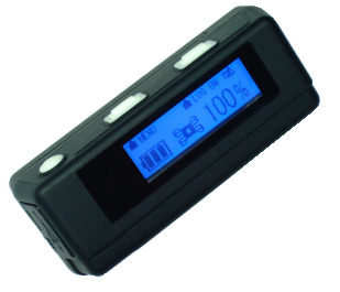
The first model of TripMate 850 purchased in 2009 had a firmware system that could not be upgraded and this model had problems with southern hemisphere latitudes (described in the review post below). We were sent a second one with the newer firmware that works globally. Thus, ARF's Tripmate 850 #1 is for northern latitude use only, Tripmate #2 works everywhere.
Interesting review/discussion of first generation unit:
http://forums.vso-software.fr/my-tripmate-850-impressions-fieldtest-t10953.html
[2010] The menu system is still elaborate but the substantial problems have been solved with newer firmware upgrades.
Prior to fieldwork users should sync wristwatches and clocks in all digital cameras to the GPS clock in the data logger and then after fieldwork is complete photos can be geolocated to positions logged by the Datalogger using software.
Download and Convert Datalogger Data files
How to download data from Tripmate 850 and convert to Shapefile for use in Google Earth or GIS software.
- Connect device as an external USB device
- Browse device and copy .NMA files across to computer. As with all new field data, make a backup of your original files from the instrument before processing them further on the computer
- For each NMA file open file in a text editor (may be too large for simple editors, use more powerful editors like Notepad++ (Windows) or Smultron (Mac), but do not use a word processor like Microsoft Word.
- Delete the first line that reads: /******************************************************************************/
- Save the file and change the suffix from filename.NMA to filename.NMEA
- Open Google Earth basic (v6) and load the .NMEA file under File > Open... change the file type to GPS (GPX, NMEA...)
- The file should load and be visible in GoogleEarth. To move it to a GIS program expand the Datalogger file in the GE Places menu
- Drill down in the Tracks folder to the Points and Path files: Tracks > [no name] > Points ...Path
- Points contain rich attribute data like Lat/Long, Altitude, Date/Time, Heading, and Est. Speed. Path is already polyline (however path can always be generated from Points in a GIS program).
- Right click Points file and use Save Place As... to save the file as a .KMZ files. You may want the Path file as well
- Many programs can open KMZ files directly including Arcmap (ArcToolbox > Conversion Tools > From KML > KML to Layer).
- Note that Arcmap specifies KML but the tool can handle KMZ files as well. KMZ is simply zipped KML (and thus much smaller).
- This file is in the following coordinate system: Decimal Degrees WGS 1984. In Arcmap use ArcToolbox > Projections > Feature > Project to convert to match the coordinate system of your other data if they differ.
Description from manufacturer:
TripMate850 features easy-to-use, cost-effective portable GPS logger solution. When you travel in different countries, it allows you to record your routes by ways of time/ distance/ speed. TripMate850 equips with one inch LCD for display of time, speed, distance measurement and position information. Through user friendly utility software, it can combine your pictures and record routes showing on the map. This recorder is small and robust, ideal to carry around for applications such as route tracking, mountain climbing and fleet management.
| Key Features: | Applications: |
| • MTK 3329 chip with 66 channel capability • Smart log function • Smart power saving with sensor • Micro SD card for unlimited storage • 1" LCD easy display • Support AGPS • Track back to POI • Powered by AAA battery*2 • Receiver & data logger dual function design |
• Show your photos on Google Map • Support photo Geo Tagging • Record your travels and show on Google Earth |
| Category | Parameter | Description |
| General | GPS Chip | MTK |
| Frequency | L1,1575.42 MHZ | |
| C/A Code | 1.023MHz chip rate | |
| Channels | 66 CH for tracking | |
| Antenna | Built-in patch antenna with LNA | |
| Datum | WGS-84 | |
| Acquisition | Cold Start | 35 sec, average |
| Warm Start | 34 sec, average | |
| Hot Start | 1.5 sec, average | |
| AGPS | <15sec | |
| Power | Battery | AAA battery |
| Operation Time | Up to 12hrs | |
| Power On/Off | Push button | |
| Environmental | Operating | -10°C to +60°C |
| Storage | -20°C to +60°C | |
| Charging | 0°C to +45°C | |
| Relative Humidity | 5% to 90% non-condensing | |
| Accuracy (none DGPS) |
Position | Without aid: 3.0m 2D-RMS DGPS: 2.5m, 2D-RMS |
| Velocity | Without aid: 0.1m/s DGPS: 0.05m/s |
|
| Sensitivity | -165dBm (tracking) | |
| Dynamic | Altitude | <18,000m |
| Velocity | <515m/sec | |
| Acceleration | 4G | |
| Interface | Bluetooth | version 1.2 compliant Class2 (over 10M in free space) |
| SD | Micro SD card | |
| Frequency | 2.4 to 2.4835GHz | |
| USB Bridge | Fully compliant with USB2.0, 12Mbps | |
| Protocol | NMEA-0183 (V3.01) - GGA, GSA, GSV, RMC (default) Data bit: 8, stop bit:1 (Default) |
|
| Physical | Dimension | 72 x 27 x 25 mm |
| Weight | 57.5g (with battery) | |
| Others | LCD | Pixel: 128*32 pixel Size: 28*8.5mm |
| Certification | CE / FCC |


